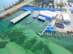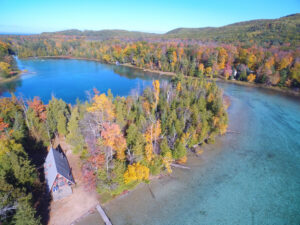

One of the questions we hear most often is whether drone photography actually helps a listing. Is it worth the investment, or is it simply a nice extra? In many cases, yes. Especially in Northern Michigan, aerial photography helps buyers appreciate features that simply can’t be seen from the ground.
Here’s why drone photography makes a difference, when it’s worth including, and how it helps showcase the right properties.
Why Aerial Photos Matter More Here Than in Most Markets
Northern Michigan isn’t a typical suburban market. A large share of what agents are selling isn’t just the house. It’s the lot, the shoreline, the woods, the privacy, and the view. Ground-level photos can show a kitchen or a living room well, but they can’t show what makes a five-acre wooded parcel or a piece of waterfront property special.
That’s where aerial photos change the equation. A drone shot of a property on Grand Traverse Bay shows the shoreline, the dock, and how close the water actually is. A drone shot of a wooded lot shows the acreage, the tree line, and the privacy buyers are paying for. None of that comes through from the driveway.
Buyers relocating from out of state make up a meaningful share of the market here too. Many of them are searching listings from hundreds or thousands of miles away and forming their first impression entirely from photos. For buyers relocating to Northern Michigan, a professional aerial photo often helps them understand a property’s setting long before they schedule a showing.
Timing plays into this as well. Northern Michigan looks different in every season, so planning a drone shoot around the best weather and lighting helps showcase a property at its best. A wooded lot photographed in July looks very different from the same property in October or under snow cover. Winter listings can still benefit, particularly for properties near ski areas or with year-round water access, but timing the shoot around good weather and daylight matters more in the off-season.
Why More Agents Choose Drone Photography
Over the years, we’ve seen aerial photography attract more attention for listings where the land, waterfront, or surrounding location is a major selling point. A strong aerial image often becomes the photo that captures a buyer’s attention first.
This matters even more for properties where the land or setting is part of the value. A waterfront home, an acreage parcel, or a property near a golf course or ski resort benefits from aerial photos in a way a standard subdivision home might not.
Drone photos also help buyers understand context that’s hard to explain in a listing description. How close is the neighbor? How much privacy does the tree line actually provide? What does the property look like relative to the water or the road? These are questions aerial photos answer immediately, where text descriptions often fall short.
What Buyers Can See From the Air
Professional aerial photography helps buyers understand the property’s surroundings in a way ground-level photos simply can’t.
For waterfront properties, aerial shots typically show the shoreline, the dock or water access, and how the property sits relative to the water. For wooded or acreage properties, they show the tree coverage, clearings, trails, and how much usable land is actually there. For properties near recognizable Northern Michigan landmarks, whether that’s a specific bay, a ski hill, or a well known road, aerial shots can place the property in context in a way buyers immediately understand.
Drone photography can also be valuable for commercial properties, helping showcase parking, access, and the surrounding area.
Larger commercial properties, apartment communities, and campgrounds also benefit because buyers can better understand the property’s size and layout.
When Drone Photos Make the Biggest Difference
Not every listing needs drone photography, and we tell agents this directly. A small condo in town with no notable lot or view typically doesn’t benefit much from an aerial shot. The investment makes more sense in specific situations.
Waterfront or near water properties benefit significantly, since the water itself becomes part of the selling point. Properties with significant acreage benefit as well, since ground photos can’t convey how much land is actually included. Properties with a distinct or scenic setting, whether that’s a hilltop, a wooded lot, or proximity to a well known landmark, also benefit. Rural properties where the surrounding land and privacy matter as much as the home itself are strong candidates too. And commercial properties where location and accessibility are part of the pitch to a buyer or tenant round out the list.
For a standard in town home on a typical lot, ground photos combined with strong interior shots are often enough. Drone photography works best as an addition when there’s something specific it can show that ground photos can’t.
Common Mistakes With DIY Drone Photos
We see this a lot. An agent or homeowner picks up a consumer drone and takes a few aerial shots themselves. Sometimes this works fine for a quick social media post. It rarely works as well as professional aerial photography for an actual listing.
The biggest issues usually come down to timing, image quality, and experience. Professional drone photography creates consistent, high-quality images that work seamlessly with the rest of your listing photography. The aerial images often don’t match the quality or consistency of the rest of the listing photos. And perhaps most importantly, flying a drone commercially, meaning for a paid transaction like a real estate listing, legally requires an FAA Part 107 license. Working with a licensed operator helps ensure every flight is completed safely and legally.
A licensed drone operator also understands local airspace restrictions. Some areas of Northern Michigan fall within controlled airspace, so every flight needs to be checked before takeoff. That’s one more reason DIY drone photos carry more risk than many agents expect.
What Goes Into a Professional Drone Shoot
Every drone project begins with planning. We review the property, confirm flight conditions, and make sure everything can be completed safely before we arrive on site.
Every image is professionally edited so the aerial photos match the quality and style of the rest of your listing photography. The final aerial images are delivered with the rest of your listing photography, creating one consistent marketing package.
Because weather can change quickly in Northern Michigan, we occasionally reschedule flights to ensure the best possible results.
How This Fits Into Marketing a Listing
Drone photography works best when it’s part of a complete marketing package that includes professional photography, virtual tours, and other listing media. This is especially effective for listings that get shared across multiple platforms, since the aerial shot often becomes the image used for social media and print marketing.
For listings with real land or water value, we usually recommend pairing drone photos with a short aerial video clip as well. A short aerial video can also help buyers better understand the property’s layout and surroundings.
Brochures, postcards, and open house materials benefit from a strong aerial shot as the lead image, since it gives potential buyers an immediate sense of the property before they even read the listing details.
How We Approach Drone Photography
At BlueLaVaMedia, drone photography is one part of the complete real estate marketing services we provide throughout Northern Michigan. Every flight is completed by a licensed FAA Part 107 certified drone operator, and every image is professionally edited to match the rest of your listing photography.
Every property is different, so we talk with agents about whether drone photography actually fits the listing before recommending it, rather than adding it to every package by default.
The Bottom Line
Drone photography can make a real difference when a property’s setting is one of its biggest selling points. Waterfront homes, acreage, rural properties, and commercial listings often benefit the most because aerial photography helps buyers understand what makes those properties unique.
If you’re preparing a listing and want to know whether drone photography makes sense for the property, take a look at our aerial drone services page or get in touch with our team. We’d be happy to talk through your listing and help you decide whether drone photography makes sense for your property.
Frequently Asked Questions
Do drone photos actually help homes sell faster?
For properties where land, water, or setting are part of the value, yes. Aerial photos give buyers the context that ground-level photos can’t provide before they schedule a showing.
Is drone photography necessary for every listing?
No. Standard in town homes on typical lots often do fine with ground photos alone. Drone photography makes the most sense for waterfront, acreage, rural, or commercial properties where the surrounding land matters.
Do I need a licensed drone operator for real estate photos?
Yes. Flying a drone commercially for a paid listing requires an FAA Part 107 license. Working with a licensed operator helps ensure every flight is completed safely and legally.
What happens if the weather doesn’t cooperate on shoot day?
We reschedule. Wind, rain, and cloud cover all affect both safety and image quality, so we build flexibility into scheduling rather than flying in poor conditions.
Can drone photos be used for video as well as photos?
Yes. A short aerial flyover often pairs well with still photos, especially for properties with significant land or water frontage.
How is drone pricing typically structured?
Drone photography is usually offered as an add on to a standard photography package, priced separately from ground photos since it involves additional equipment, licensing, and flight time.
Does drone photography work for listings without water or land features?
It can, though the value is smaller. A standard subdivision lot with no notable view or acreage typically doesn’t need aerial photos. In those cases, ground and interior photos usually carry the listing on their own.