
When buyers begin searching for a home or commercial property, the first thing they notice isn’t the description. It’s the photos. Within seconds, they decide whether a listing is worth exploring or whether to move on.
In Traverse City, ground-level photography doesn’t always tell the whole story. Waterfront homes, vineyards, luxury properties, and commercial buildings often have features that can only be fully appreciated from above.
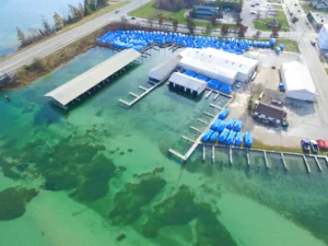
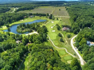
This is where aerial photography services add another dimension to professional real estate photography By capturing a property from above, drone imagery helps buyers understand its setting, scale, and surrounding environment in ways ground-level photos cannot.
Combined with interior photography, virtual tours, and other visual marketing tools, aerial imagery creates a more complete online presentation that helps buyers make informed decisions and helps listings stand out.
What Are Aerial Photography Services?
Aerial photography has become a standard feature of modern real estate marketing, helping showcase properties from perspectives that traditional photography cannot provide. Using professionally operated drones, photographers capture unique overhead views that help buyers understand a property’s location, layout, and outdoor features. Rather than focusing only on what can be seen from the street, aerial imagery reveals how the property connects with its surroundings, highlighting features that ground-level photography often misses.
A professional aerial photography session can highlight features that are difficult or impossible to appreciate from the ground, including lot size, roof condition, landscaping, waterfront access, neighboring properties, nearby amenities, and the relationship between the property and the surrounding community. For larger residential properties, commercial developments, hotels, apartment communities, schools, and rural estates, this additional perspective often becomes one of the most valuable parts of the marketing package.
For Traverse City listings, overhead imagery highlights the features that often influence buying decisions most, from waterfront access and vineyard acreage to scenic surroundings and neighborhood context. A single aerial image can help buyers understand whether a home sits directly on the shoreline, how much privacy the property offers, how close it is to Grand Traverse Bay, or how the surrounding landscape contributes to its overall appeal.
Today’s buyers expect more than a gallery of photos. They want to explore a property online and understand how it looks and fits into its surroundings before deciding whether it’s worth visiting in person. Many real estate photography packages now combine drone photography, interior photography, virtual tours, floor plans, and property websites to give buyers a complete picture of the home before they schedule a showing.
Why Buyers Expect More Than Standard Property Photos
Buying a property almost always begins online. Before contacting an agent or scheduling a showing, buyers spend time comparing listings, reviewing photographs, and narrowing their options from dozens of available properties.
According to the 2024 Profile of Home Buyers and Sellers published by the National Association of REALTORS®, every home buyer surveyed used the internet during their home search, while 43% said searching online was the very first step in their buying journey. The same report also found that property photos were the most valuable feature on real estate websites, with 41% of buyers identifying them as the information they relied on most.
These findings highlight an important shift in buyer behavior. Listing photos are no longer simply supporting content. They have become one of the primary factors influencing whether buyers continue exploring a property or move on to another listing.
For buyers considering Traverse City real estate, strong visuals are especially important. Many prospective purchasers travel from other parts of Michigan or from states such as Illinois, Indiana, Ohio, and Florida to purchase waterfront homes, vacation properties, retirement residences, or investment properties. In many cases, buyers shortlist properties before ever visiting Northern Michigan, making online presentation one of the most influential stages of the buying process.
High-quality listing photos, supported by aerial imagery, answer many of the questions buyers naturally ask while browsing homes online.
- How large is the property?
- What surrounds the home?
- How close is it to the water?
- What does the neighborhood look like?
- Is there enough outdoor space?
- How accessible is the property?
Instead of trying to imagine what’s beyond a few exterior photos, buyers can clearly see the property’s setting, surroundings, and location through professionally captured drone images. This wider perspective helps buyers evaluate whether a property matches their needs before contacting an agent or arranging a viewing.
For real estate professionals, drone photography isn’t about creating dramatic images. It’s about giving buyers the visual information they need to understand a property’s setting, evaluate it with confidence, and decide whether it’s worth scheduling a showing.
What Buyers Can See from the Air That Ground-Level Photography Misses
Ground-level photography is essential for showcasing a home’s interior and exterior, but it has natural limitations. A camera positioned at eye level can only capture what’s directly in front of it. It can’t show how the property sits within the neighborhood, how much land surrounds it, or how nearby features contribute to its value.
Overhead images reveal details that are difficult to communicate from ground level, including the property’s boundaries, surrounding landscape, and relationship to nearby landmarks.
Buyers can immediately see whether a home sits directly on Grand Traverse Bay, how much privacy the lot offers, where neighboring properties are located, and how outdoor spaces connect to the rest of the property.
The difference becomes even more noticeable for larger homes, waterfront properties, commercial buildings, apartment communities, hotels, schools, and rural estates where location and surroundings influence buyer interest just as much as the building itself.
| Feature |
Ground-Level Photography |
Aerial Photography |
|
Lot size and boundaries |
Limited or difficult to judge |
Clearly visible from above |
|
Roof layout and condition |
Partially visible |
Easily viewed |
|
Waterfront location |
Difficult to communicate |
Immediate visual context |
|
Relationship to neighboring properties |
Limited |
Clearly understood |
|
Landscaping and outdoor amenities |
Partial view |
Complete overview |
Rather than replacing professional real estate photography, aerial imagery complements it. Interior photographs show buyers what it’s like to experience the home, while aerial images reveal its location, surroundings, and the features that add value beyond the property itself.
For Traverse City buyers comparing several listings online, that additional context often makes one property easier to understand than another before they ever schedule a visit.
Which Traverse City Properties Benefit Most from Aerial Photography?
While almost every listing can benefit from aerial photography, some properties gain considerably more value because their location, setting, or land is one of their primary selling features.
Waterfront Homes
Traverse City’s waterfront properties attract buyers from across Michigan and throughout the Midwest. Buyers naturally want to understand shoreline access, dock placement, beach frontage, neighboring homes, and views across Grand Traverse Bay. Aerial photography provides that perspective immediately, helping buyers appreciate the property’s location before they arrive in person.
Luxury Homes
Luxury listings benefit from a polished visual presentation that reflects the property’s quality and value. High-quality aerial photography showcases architectural design, landscaped grounds, outdoor entertaining areas, swimming pools, guest houses, and the overall scale of the property in ways that traditional photography cannot.
Vineyards, Farms, and Rural Properties
Large parcels of land are difficult to represent from the ground. Drone photography allows buyers to see acreage, vineyard layouts, tree lines, access roads, outbuildings, and surrounding countryside in a single set of images, making it much easier to understand the property’s full potential.
Commercial Properties
Commercial buyers and investors evaluate more than the building itself. They also consider parking availability, vehicle access, nearby businesses, traffic flow, and the property’s relationship to surrounding developments. Aerial imagery helps communicate these important factors far more effectively than standard exterior photography.
Hotels, Resorts, and Hospitality Properties
Hotels and resorts rely heavily on visual marketing. Drone photography showcases building layout, outdoor amenities, surrounding attractions, waterfront access, recreational areas, and proximity to downtown Traverse City, giving potential guests and investors a much better understanding of the property’s appeal.
Apartment Communities
For apartment developments, buyers, investors, and prospective tenants often want to understand the overall community rather than just individual units. Aerial photography highlights shared amenities, green spaces, parking areas, walking paths, and the relationship between buildings, creating a more complete picture of the community.
Schools and Educational Campuses
Educational institutions frequently use aerial photography to showcase campus size, athletic facilities, playgrounds, parking, and surrounding neighborhoods. These images help families, prospective students, and community partners better understand the campus before visiting.
Creating a Complete Visual Marketing Experience
Aerial photography becomes even more valuable when it’s combined with other real estate photography services instead of being used on its own.
Combining aerial imagery with professional real estate photography, Zillow 3D Tours, floor plans, and dedicated property websites creates an engaging online experience that helps buyers explore a property before scheduling a showing.
A buyer may first notice an aerial photograph showing the property’s surroundings and location. From there, they move through professionally photographed interiors, explore the home’s layout using a virtual tour, and review additional property details before contacting an agent. Each visual element builds on the previous one, giving buyers greater confidence that they understand the property.
This approach is particularly valuable for Traverse City, where many buyers begin their search from outside Northern Michigan. Instead of relying on a handful of exterior photographs, remote buyers can gain a much clearer understanding of the property’s setting, layout, and lifestyle benefits before making the trip to view it in person. For larger lots, waterfront properties, and vacant land, enhanced property line overlays can also help buyers clearly understand property boundaries from an aerial perspective.
For real estate professionals, combining multiple visual marketing services also creates a more consistent presentation across MLS listings, property websites, social media campaigns, digital advertising, brochures, and email marketing. Rather than treating aerial photography as an optional add-on, it becomes an integral part of telling the property’s story across every marketing channel.
Why FAA Certification Matters When Hiring an Aerial Photography Company
Professional aerial photography involves far more than flying a drone and taking pictures. Every commercial drone flight in the United States is regulated by the Federal Aviation Administration (FAA), and anyone providing aerial photography services for compensation must operate under 14 CFR Part 107.
To obtain a Remote Pilot Certificate, drone pilots must pass an FAA aeronautical knowledge exam, register their aircraft, and complete recurrent training to maintain certification. These requirements help ensure pilots understand airspace restrictions, weather conditions, emergency procedures, and safe operating practices.
Working with FAA Part 107-certified drone pilots helps ensure aerial photography is completed safely, legally, and professionally while complying with federal regulations for commercial drone operations. It also helps reduce potential regulatory, insurance, and liability risks associated with commercial drone operations.
This is especially important in Traverse City. Because of the controlled airspace surrounding Cherry Capital Airport, some locations require FAA authorization before a commercial drone flight can take place. An experienced Part 107 pilot understands how to obtain these approvals and plan flights that comply with current regulations without creating unnecessary delays for a listing.
While image quality is important, professionalism, safety, and regulatory compliance should be equally important factors when choosing an aerial photography provider.
How to Choose the Right Aerial Photography Company
Not every company offering drone photography provides the same level of experience or service. Choosing the right provider involves more than comparing prices. The quality of the images, the photographer’s experience, turnaround times, and the ability to support your overall marketing strategy all contribute to the final result.
Before booking an aerial photography service, consider asking the following questions:
- Is the drone pilot currently FAA Part 107 certified?
- Does the company carry commercial liability insurance for drone operations?
- Can they provide examples of similar residential, waterfront, luxury, or commercial projects?
- How quickly will the edited images be delivered?
- Are the final files prepared for MLS listings, property websites, and digital marketing?
- Can aerial photography be combined with professional real estate photography, Zillow 3D Tours, floor plans, property websites, and other visual marketing services?
- Does the company have experience working with the type of property you are marketing?
A provider that offers multiple visual marketing services can also simplify the listing process by coordinating photography, drone imagery, virtual tours, and marketing assets through a single project rather than requiring you to work with several different vendors.
Why BlueLaVaMedia Is a Trusted Choice for Aerial Photography in Traverse City
Successful real estate marketing starts with visuals that help buyers understand a property before they visit. BlueLaVaMedia provides professional photography and aerial imaging services that help agents and property owners showcase homes, commercial buildings, and hospitality properties with clarity and confidence.
Based in Traverse City, BlueLaVaMedia has been helping real estate professionals, homeowners, builders, and businesses throughout Northern Michigan since 2007. The team specializes in professional real estate photography, aerial drone services, virtual tours, Zillow 3D Tours, floor plans, property websites, and visual marketing solutions that help properties stand out online.
Every aerial photography session is completed by FAA Part 107-certified drone pilots who follow current federal regulations and capture exceptional aerial photos. Every listing also benefits from BlueLaVaMedia’s TrueBlue photo enhancement process, which improves skies, colors, and overall presentation for a polished, professional finish. From waterfront homes and luxury properties to commercial buildings, vacation rentals, and vacant land, BlueLaVaMedia has photographed thousands of homes and completed more than 3,000 aerial drone projects throughout Northern Michigan, helping properties make a stronger first impression online.
Rather than offering drone photography as a standalone service, BlueLaVaMedia combines aerial imagery with professional photography, Zillow 3D Tours, floor plans, property websites, and visual marketing tools to help real estate professionals create engaging listings that attract more buyers.
Why Aerial Photography Continues to Shape Modern Real Estate Marketing
The way buyers shop for property has changed dramatically over the past decade. Before they ever contact an agent, request additional information, or schedule a showing, they often spend hours researching listings online and comparing properties side by side.
Ground-level photography highlights the home’s design and interior spaces, while aerial imagery showcases the property’s lot, surroundings, and neighborhood context. Together, they provide buyers with a more complete understanding of the property before they schedule a showing.
For Traverse City, where waterfront homes, vineyards, commercial properties, hotels, luxury residences, and rural estates often rely on their location as a key selling point, aerial photography provides valuable context that traditional photography alone cannot communicate.
When combined with professional real estate photography, Zillow 3D Tours, floor plans, property websites, and BlueLaVaMedia’s TrueBlue photo enhancement, aerial imagery becomes part of a complete marketing strategy that helps listings stand out and gives buyers a clearer understanding of the property before they visit.
Whether you’re marketing a waterfront home, luxury property, vacation rental, commercial building, or vacant land in Traverse City or anywhere in Northern Michigan, BlueLaVaMedia provides the professional photography, aerial drone services, Zillow 3D Tours, floor plans, property websites, and visual marketing solutions you need to showcase your property at its best. Contact BlueLaVaMedia today to schedule your next photography session.
Frequently Asked Questions
Does BlueLaVaMedia offer aerial photography services in Traverse City?
Yes. BlueLaVaMedia provides professional aerial drone photography throughout Traverse City and Northern Michigan using FAA Part 107-certified drone pilots. Drone services can be combined with professional real estate photography, Zillow 3D Tours, floor plans, property websites, and TrueBlue photo enhancement to create a complete visual marketing package.
What types of properties benefit most from aerial photography?
Aerial photography is valuable for almost any property, but it provides the greatest benefit for waterfront homes, luxury residences, vineyards, rural properties, commercial buildings, apartment communities, hotels, schools, and properties with large lots or unique surroundings. These property types often rely on location, land, or outdoor features that are difficult to communicate through ground-level photography alone.
Is FAA certification required for commercial drone photography?
Yes. Anyone operating a drone for commercial purposes in the United States must hold a valid FAA Remote Pilot Certificate under Part 107. Working with an FAA-certified drone pilot helps ensure the flight complies with federal regulations and industry safety standards.
How should I prepare my property before an aerial photography session?
Preparing the exterior is just as important as preparing the interior. Remove vehicles, garbage bins, construction materials, and other temporary items that may distract from the property. Well-maintained landscaping, clean outdoor living spaces, and favorable weather conditions also contribute to stronger aerial images. If there are features you would like highlighted, such as waterfront access, a pool, or outdoor entertainment areas, discuss them with your photographer before the session.
How does aerial photography improve an MLS listing?
Aerial photography helps buyers understand the property’s location, lot size, surroundings, and outdoor features before scheduling a showing. These additional perspectives make listings more informative and provide context that standard exterior photographs often cannot capture, particularly for waterfront, luxury, commercial, and rural properties.
Is aerial photography only useful for large or waterfront homes?
No. Even smaller residential properties benefit from aerial imagery because it provides buyers with a clearer understanding of the home’s lot, backyard, driveway, neighborhood, nearby parks, and surrounding amenities. These details help buyers visualize the property’s setting and how it fits into the local community.